
Weather or Not | Predicting your day on Hood Canal
While talking about the weather is traditionally deemed the safest subject in polite company, predicting it definitely lands you in a volatile position, as weather forecasters who try to explain the many unique weather patterns we get along the Hood Canal can attest. From beautiful dry summers, to drizzly falls, stolen snow days and unexpected hurricane force winds– the weather of the Hood Canal never fails to surprise. Although it’s fun, it’s not fair to blame our mercurial weather on forecasters based in Seattle.
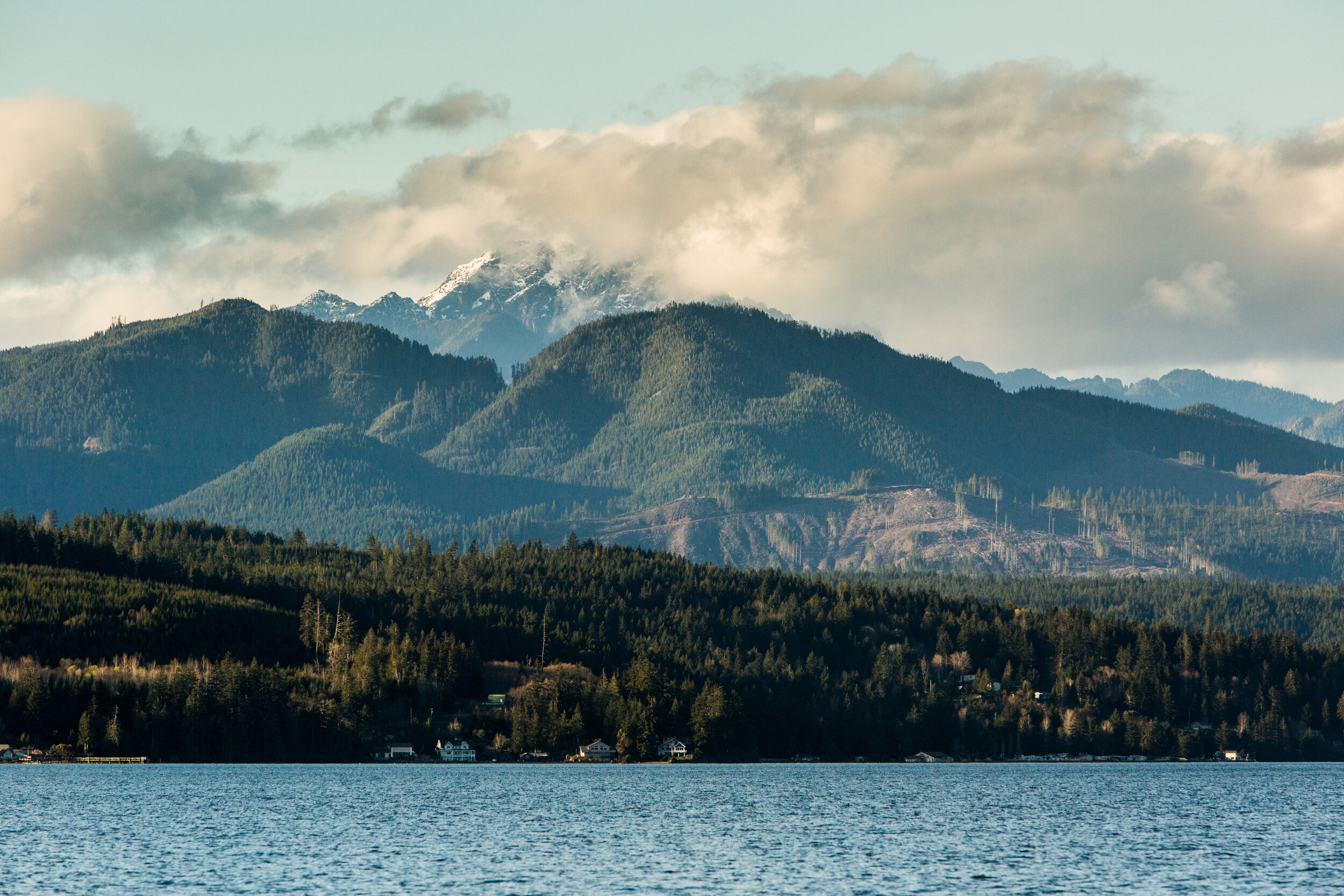
The fjord we call Hood Canal, flanked by the lofty Olympic Mountains to the west, creates a unique geography that is not only picturesque, but also results in weather systems that are very tricky to predict.
Although likewise coastal, Hood Canal experiences far more instances of snow than Tacoma or Seattle. Unlike other Washington coastal communities, the saltwater corridor of the tidal Hood Canal is too narrow to sufficiently warm the air.
Another factor influencing snow fall is the location of the Olympic Mountains. Traditionally, weather is known to travel from the west off the Pacific Ocean to the East. Following this we would expect that because of its location lying in the eastern lee of the Olympic Mountains the Hood Canal would be protected from these weather systems, but that is not how the weather always behaves. Low pressure systems off the Pacific often results in high pressure weather in Washington’s Northeast, which reverses this lee and draws weather in an East to West direction. Also cold air from the mountain tops often falls down into the fjord rapidly dropping the air temperature.
This cooler, snow ready weather makes winter sports an unexpected pleasure of the Hood Canal. Many locals take advantage of this 4x4’ing in the mountains on the weekend for snowy tailgate parties.
Sometimes the community joins in on the festivities. Last year, Quilcene hosted a community snowball fight after a particularly white week. However, recent snow falls have been fairly tame in comparison to the four feet of flakes Hoodsport received in 1916 or twenty-seven inches in 1943!

Since the Hood Canal is fed by the estuaries of the Skokomish, Union and Hamma Hamma Rivers along with a number of smaller tributaries, it has a layer of freshwater atop the salt. In very cold weather, this brackish water has been known to freeze over. In the winter of 1924-25 the Hood Canal froze from Lilliwaup to Belfair. In typical pioneering spirit, there are many historical accounts of exploiting this new surface. There were reports of the Twana elder Henry Allen driving his wagon across the canal from Hoodsport.
Frank Pixley who founded the artist colony of Olympus Manor at Union reportedly walked across to Tahuya. Fritz Dalby (of the Dalby Waterwheel fame in Union) went ice-skating in front of the current site of the Robin Hood Restaurant. The Hood Canal is reported to have frozen over in 1950, 2009 and most recently in 2015.
A similar low-pressure vacuum that makes Hood Canal prone to snowstorms also can result in heavy winds. In the summer-time this weather calms down to gentle breezes, which makes the straight stretch of Hood Canal a favorite with sailing clubs.
However, during the winter these winds can get fierce. One windstorm that hit in February of 1979 was particularly infamous. A low pressure moved in the Juan de Fuca Strait drawing all the air of Western Washington into tremendous winds. Unfortunately, Hood Canal with its deep fjord shape and its South-North orientation lined up perfectly with the direction of this wind and created a powerful wind tunnel.

The floating Hood Canal Bridge connecting the Kitsap and Olympic Peninsula located at the mouth of the Hood Canal could not stand the winds that reached 80 m.p.h with estimated gusts of 120 m.p.h. Although the bridge crew opened the bridge to help relieve the stress of the buffeting wind, the bridge’s pontoon storm hatches blew open and the bridge took on water. No one was hurt, but on February 13th 1979 the world’s longest saltwater floating bridge sank. What was usually a 1.5 mile bridge crossing became a 115 mile detour around the Hood Canal inconveniencing thousands of commuters. WSDOT scrambled to re-establish ferry routes between Lofall and South Point across the canal just south of the bridge and extra ferries were added to the route between Edmonds and Port Townsend. The bridge was repaired and reopened on October 24th 1982 with heavier anchors and more stringent bridge closure procedures. Many called for the bridge to be replaced with a spanned bridge that wouldn’t be at the mercy of the 16.5 foot tides, the corrosive quality of salt water, and the strong currents, but the fjords 300 + depth and sandy bottom is too difficult and cost prohibitive to span. Today, approximately 20,000 vehicles cross the bridge daily and in the last forty years the bridge has not suffered such a failure again.
While the wind, snow, rain, and sudden brilliant sunny days make it hard to pack for a visit on the Hood Canal, don’t let the weather deter you. Pick a book and snuggle beside by the fire and enjoy the hygge you keep hearing about while the misty damp engulfs the trees outside. Or pull on your gumboots and favorite slicker and meet the storm full on – storm-watching and puddle jumping can be pretty fun too! But if it snows, dust off your favorite hot toddy recipe and challenge your friends to an igloo building contest. Embrace the unexpected, it’s the Northwest way.
Contributor: Stella Wenstob, MA