
Silver Lake Hike
Craig Romano | Story and Pictures
The Olympic National Forest’s Buckhorn Wilderness contains more than 44,000 acres of some of the finest backcountry on the Olympic Peninsula. Within this rugged corner of the Olympic Mountains you can hike on miles of trails traversing deep valleys of old-growth forests and along high windswept ridges granting stunning views.
Hit the Trail
Located within the Olympic rain-shadow, the Buckhorn receives ample sunshine and consists of a much drier landscape than points south and west. Lakes are rare in this wilderness. Silver Lake is one of the few gracing the region. It provides an oasis for wildlife and serves as an excellent destination for hikers.
There are two ways to reach Silver Lake. The shorter route is via Silver Creek. This route was never officially built, involving instead from a well-trodden user built boot path. It’s rugged in spots and to reach it involves a long rough dirt road from the north. The official trail starts high on the southern shoulder of Mount Townsend. It involves more effort to hike due to its length and elevation gain—but it’s well-built and highly scenic. And the approach to it is by a primarily good paved road.
Nearby Mount Townsend—one of the most popular hiking destinations in the Olympics keeps most hikers away from these trails, leaving Silver Lake a much quieter destination. In early season wildflowers give an added bonus to the official route—but lingering snow can make it tricky.

"Fall is the perfect time to visit Silver Lake with the added bonus that its resident biting insects have gone the way of the early blossoms."
Start your hike from the upper trailhead for the Mount Townsend Trail. Follow this well-worn & popular path through stately groves of firs and hemlocks adorned with Pacific rhododendrons. In late May and early June, the rhodies add an array of dazzling colors to the surrounding verdant cloak. The trail steadily climbs. Shortly after entering the Buckhorn Wilderness, the forest cover thins and views east emerge. Cross several cascading creeks and continue working your way upward. The trail switchbacks more than two dozen times.
The way crests a small knoll arriving at Camp Windy, which usually lives up to its name. Look below to tiny Windy Lake, not much more than a buggy pool most of the year. Then continue climbing coming to a junction at 3.0 miles.

Here most hikers will continue right to ascend the open summit of Mount Townsend. You want to head left on the trail less traveled. Your climbing isn’t yet over however. Muster up a little more energy and reach a small gap on a high ridge separating Mount Townsend from the Welch Peaks. Take a break and look back east for a great view of Windy and Sink Lakes directly below. Then face west and enjoy a sweeping view of the Silver Creek valley. Silver Lake however is not visible. It’s hidden behind a small wooded knob to the south.
Now resume hiking crossing a steep slope that comes alive with blossom in the summer. Via a couple of long switchbacks the way descends more than 600' into the valley. Be sure to save some energy for the return hike, as you’ll need to regain that elevation. At 4.6 miles reach a junction in the forested valley. Here the Silver Lake Way Trail descends northwest following alongside Silver Creek. Continue straight, soon coming to Silver Creek.
Hop across the creek and start climbing again following the creek to its source.

At 5.4 miles reach Silver Lake in a semi-open bowl flanked by craggy peaks and ridges. It’s a tranquil spot where soft breezes often leave rippling signatures on the lake’s surface; and the raucous calls of Clarks nutcrackers (more common east of the Cascade Crest) often break the silence.
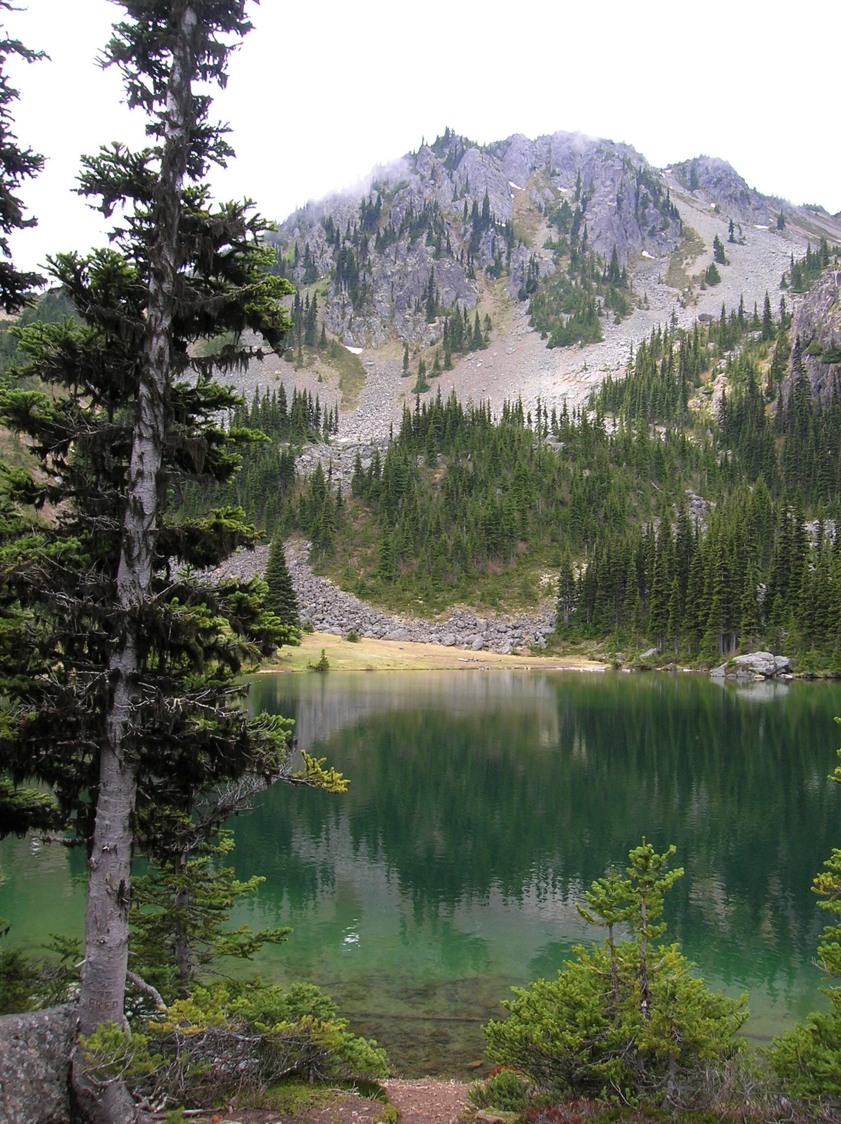
Find a shoreline rock and stay for a while. However, if you have some energy left, a steep half mile path to the south may entice you to follow it. It leads to a gap on a ridge high above the Big Quilcene River where you can stand mouth agape staring out at hulking Mount Constance towering over craggy ridges and deep emerald valleys.

Craig Romano is an author of more than 20 hiking guidebooks including the bestselling Day Hiking Olympic Peninsula 2nd Edition (Mountaineers Books), which includes descriptions for 136 hikes throughout the Olympic Peninsula. He is a regular contributor to Explore Hood Canal. Also check out his list of 25 Olympic Peninsula waterfalls at waterfalltrail.org.
Silver Lakes Notes
Distance: 10.8 miles round-trip
Elevation Gain: 3275 feet (High Point: 5675 feet)
Difficulty Loop: difficult
Snow free: mid-June to early November
Trailhead Pass Needed: Northwest Forest Pass or Interagency Pass
GPS waypoints:
Trailhead: N47 51.385, W123 02.153,
Silver Lake: N47 50.686 W123 04.247NW Forest pass required; Wilderness rules
Land Agency Contact: Olympic National Forest, Hood Canal Ranger District, Quilcene, (360) 765-2200; fs.usda.gov/olympic
Recommended Map:
Green Trails Olympic Mountains East 168SRecommended Guidebooks: Day Hiking Olympic Peninsula 2nd edition (Romano, Mountaineers Books)
Trailhead directions: From Quilcene drive US 101 south for 1.5 miles and turn right onto Penny Creek Road. After 1.5 miles bear left onto Big Quilcene River Road (Forest Road 27); which eventually becomes paved. Continue on FR 27 for 13.7 miles and turn left onto FR 27-190 reaching the trailhead in 0.7 mile.
Tips for safe and healthy hiking during the Covid-19 Pandemic
We all must do what we can to prohibit the continual spread of this disease. We can do that by adhering to the following while we enjoy our trails:
• Avoid crowded hiking destinations. If you arrive and the parking lot is already full, head to another location
• Opt for weekdays over weekends to hit the trail
• Hit the trail early morning before others arrive
• Avoid hiking in large groups outside of family
• Practice Social Distancing while on the trail, giving other hikers room to pass and keeping your distance from them at lakes and summits.
• Wear a mask when encountering others on the trail. A buff or bandanna works well.
• Pack hand sanitizer
• Pack it in pack it out
• Don’t be a surface pooper. Poop properly in the woods by always using privies first if available-or by heading at least 200 feet away from all trails, campsites and water sources and digging a cat hole for your business. Bury waste and TP.
• Pack out all pet waste.